
Backpacking The Upper Yosemite Point Loop Trail
This is a post about Hiking The Upper Yosemite Point Loop Trail in Yosemite National Park in California.
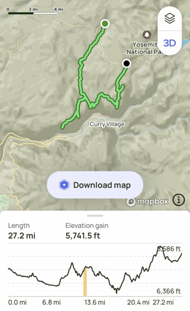
Important Information & Stats:
- Trailhead Location: Yosemite Creek Trailhead (parking lot), Yosemite National Park, California, USA
- Type: Backpacking Loop Hike (2 vehicles [or a drop] off required from Porcupine Creek Trailhead (parking lot) to Yosemite Creek Trailhead (parking lot)
- Direction Hiked: Counter-clockwise
- Permits Required: Yes
- Mileage: 27.2+ Miles(ish)
- Elevation Change: 5741.5 feet
- Duration: 3 days/2 nights (not counting drive time)
- Parking: Yosemite Creek Trailhead (parking lot); there is an overflow [dirt] parking lot across the street
About The Upper Yosemite Point Loop Trail
Hiking from the Yosemite Creek trailhead to Upper Yosemite Falls (camping area) is a journey that offers a mix of forested paths and impressive views. The trail makes a stop at Eagle Peak before continuing on to Upper Yosemite Falls, Yosemite Point, and North Dome – providing hikers with sweeping views of Yosemite Valley and Half Dome. After passing by Indian Rock, the route concludes at Porcupine Creek trailhead, where backpackers then catch a ride back to the parking lot at the Yosemite Creek trailhead.
DAY 1
Hiking from Yosemite Creek trailhead to the Upper Yosemite Falls backcountry camping area covers around 9 miles (for some reason, many published mileages stated [around] “5 miles”, but our various GPS devices clocked it at 9 miles) with a slow gradual decent in elevation to the “non-official” Upper Yosemite Falls campground area (which can be found on an unmarked but conspicuous trail that veers east up a hill, toward Yosemite Creek; this is just North of the junction with the trail to Eagle Peak).
From the parking lot, the trail heads generally downhill, meandering alongside Yosemite Creek, eventually meeting up with the [now defunct] Yosemite Creek Campground. From there, the trail continues through forested areas where you’ll encounter many fallen tress and several burned out areas. As you progress, you’ll follow a granite cliffside ridge along Yosemite Creek where you’ll be treated to amazing views of its various cascades.
DAY 2
Hiking from the Upper Yosemite Falls campground area to Eagle Peak is a scenic out-and-back side-quest journey along covering approximately 4 miles round trip with an elevation gain of about 1500+ feet. From Eagle Peak, the trails links back up with the main trail to Upper Yosemite Falls, then to Yosemite Point, both of which offer spectacular views of Yosemite Valley. Unfortunately for us, we encountered the worst weather on our trip this day, so our views were, let’s just say “limited”. Nevertheless, we still had an amazing time.
From Yosemite Point, the trail makes its steepest climb, before heading through a scenic moist section of rainforest, crossing two creeks, and meeting up with the “non-official” campground at the Porcupine Creek Trail / North Dome Trail junction.
DAY 3
From the “non-official” campground at the Porcupine Creek Trail / North Dome Trail junction, the hike to North Dome covers approximately 2.2 miles with an elevation gain of about 500 feet. The trail offers picturesque views of the surrounding forest and distant peaks, including Half-Dome, Cloud’s Rest, Star King, & Glacier Point (among others) making it an epically scenic route for hikers.
Continuing from North Dome to Indian Rock, and then to the parking lot at the Porcupine Creek Trailhead, the route spans around 3 miles with a mixture of slight ascents and descents. Along the way, hikers can enjoy unique rock formations, including the natural arch at Indian Rock, several easy water-crossings, and a lush forest before concluding the hike at the parking lot.
Final Throughts: Backpacking The Upper Yosemite Point Loop Trail (Yosemite National Park)
We had initially tried to get permits for one of the more popular Yosemite backpacking routes [last-minute], but they were, of course, completely sold out. Plan B was to to find an entrance permit that was available and build a trip out of that. That’s when we found a permit for Yosemite Creek.
After consulting the map, trying to build something that would take 2nights/3 days, and triple checking mileages, I settled on what I’m calling “The Upper Yosemite Loop Trail”. I may or may not have “invented” this route, but I definitely couldn’t find this route on any website (including Alltrails), so I’m going to go ahead and take full credit.
This is a great hike for anybody looking for an epic 2 night/3 day adventure, with findable permits, a hike with challenging spots – yet overall relatively easy gradual elevation changes, plenty of water refill sources, and most importantly – epic sights along the way: Yosemite Creek, Eagle Peak, Upper Yosemite Falls, Yosemite Point, North Dome, and Indian Rock – sprinkled with sweeping views of Yosemite Valley and Half Dome thrown in.
Be safe out there, and happy trails!
1 comment
[…] This was published by Flying High On Points, to read the complete post please visit https://www.flyinghighonpoints.com/backpacking-the-upper-yosemite-point-loop-trail-yosemite-national…. […]
Comments are closed.